REPORT
The Danger Immigrants Face Crossing the Streets of Culmore
Bailey’s Crossroads Community Walkability Survey and Audit Results
Virginia
Bailey’s Crossroads Community Walkability Survey and Audit Results
Virginia
The Bailey’s Crossroads community is home to a large immigrant population where many residents rely on walking, biking and the bus to get to work and daily activities. This Virginia community has a high density of housing within a walkable distance to grocery stores, restaurants, schools, religious institutions, and other services. Yet, the main arterial road, Route 7 (Leesburg Pike) is unsafe because of missing sidewalks, few safe crossing options, bus stops without crosswalks, and heavy high-speed traffic.
The Coalition for Smarter Growth (CSG) the region’s leading smart growth organization and immigrant advocacy powerhouse CASA have partnered on a Safe Streets for Bailey’s Crossroads campaign to engage and organize local residents in the Culmore neighborhood of Fairfax County to make the community’s streets safer and improve access to walking, biking and transit. The campaign is guided by a stakeholder advisory committee of local community residents and volunteers, and the Fairfax Alliance for Better Bicycling (FABB) and Fairfax Families for Safe Streets (FfxFSS), in addition to CSG and CASA.
CSG and CASA, in coordination with the campaign’s Stakeholder Advisory Committee, developed a walkability survey to hear directly from residents their concerns about walking, biking, and accessing the bus and what they feel would make it better. We received 202 responses, which have been compiled and analyzed in this report. A walking audit was done to augment the survey and to assess and document firsthand the experience of walking along and crossing Route 7 in the Culmore neighborhood. Key observations, problem locations and supporting images from the walk audit can be viewed on the interactive google map.
Overwhelmingly, people in Culmore indicated they do not feel safe walking, biking or getting to transit. They cite crime, dangerous driving, poor lighting, lack of bike infrastructure, not enough time to cross the street, and the lack of connected sidewalks and safe crossing options.
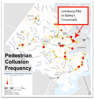
Both the Fairfax County Department of Transportation (FCDOT) and the Virginia Department of Transportation (VDOT) have identified the Route 7 corridor in this community as a high risk corridor for vulnerable road users based on years of data showing high numbers of fatalities and serious injuries.
from Fairfax County’s Safe Streets for All Program presentation (June 2021)
In developing the county’s Safe Streets for All program, FCDOT found that four out of the top 10 high risk corridors in the county for pedestrians are in Bailey’s Crossroads. Three segments are along Route 7 and one along Columbia Pike. Their presentation to the Board of Supervisors also notes that most pedestrian fatalities have been on roadways with posted speeds at 40 to 45mph such as Route 7.
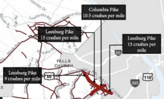
Image of High Risk Corridors from Fairfax County’s Safe Streets for All Program presentation (June 2021) Bold red line = Top 10 High Crash Rate Corridors / Thin red line = High Risk Corridors
Meanwhile, in its Pedestrian Safety Action Plan, VDOT identified Route 7 and the Columbia Pike in Bailey’s Crossroads to be within the top 1% of statewide pedestrian priority corridors based on crash data from 2016-2020. The Route 7 corridor through the Culmore community is also listed as a top 1% pedestrian priority corridor within the Northern Virginia district of VDOT.
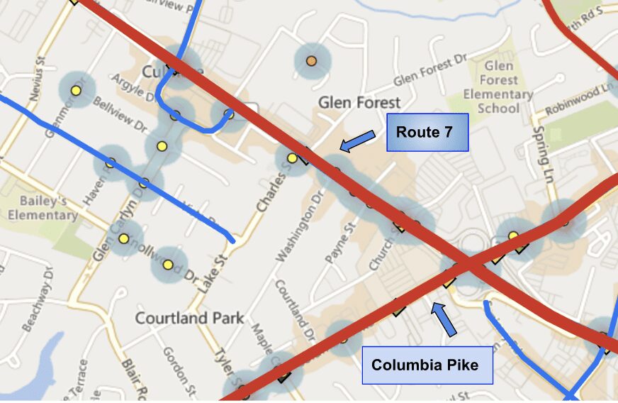
Image of Culmore community on VDOT’s Pedestrian Safety Action Plan Map Viewer 3.0 Red line = Top 1% statewide pedestrian priority corridors Blue line = Top 5% statewide pedestrian priority corridors Blue shaded areas = Bike/Ped Crash Heat Map / Colored dots = crashes
Despite these priority designations, and sidewalk additions over the past decade, not enough has been done to the Route 7 corridor to stem traffic fatalities and injuries to residents trying to navigate their community on foot or by bike.
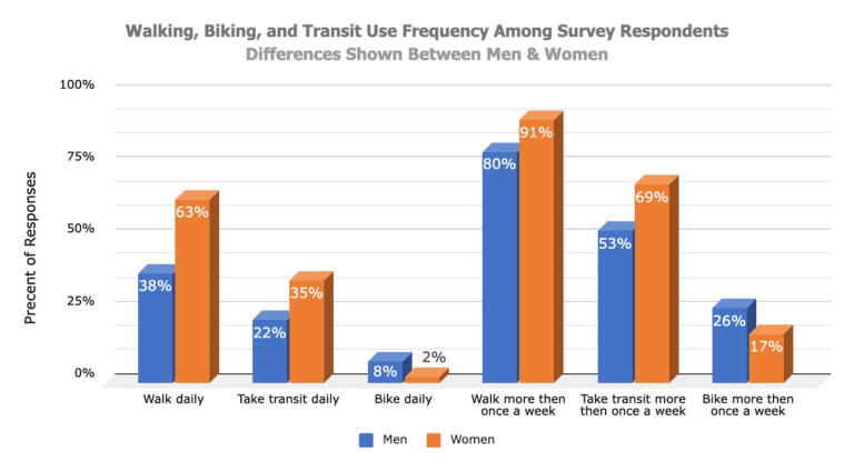
Five percent of respondents reported they bike everyday and 21% bike at least once a week. Survey respondents between 65-74 years old bike the most out of all age categories with 17% biking daily and 33% at least once a week.
There were some significant differences between men and women. 63% of women say they walk daily compared to 38% of men, and 35% of women take transit daily compared to 22% of men.
Overall, survey respondents from the Culmore community walk, bike, and use transit at considerably higher rates than Fairfax County residents as a whole. Looking at the Metropolitan Council of Government’s most recent 2017/2018 Regional Travel Survey, the mode share split for all trips in Fairfax County was 2.5% rail, .8% bus, 5.3% walk, and 0.8% bike.
Fairfax County’s Commuting Patterns Dashboard, based on the 2020 US Census American Community Survey of how commuters in Fairfax County travel to work, shows that countywide 4.5% take transit (rail and bus), 1.6% walk, and 0.2% bike.
Jose Castillo has lived in Culmore for eight years and is concerned about the safety in the area where he shops, goes to the laundry, and works. “Every day, you can see the risks in the area,” he says, “And unfortunately, there have already been human losses.” He wants to improve the safety of people traveling on this road by eliminating and reducing risk factors.
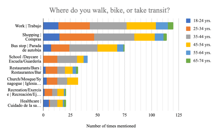
The places traveled most by walking, biking and public transit is to work and to go shopping, but many also went to restaurants, school, and places of worship.
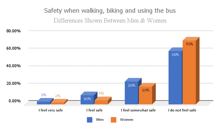
Overwhelmingly, survey respondents indicated they do not feel safe walking, biking or getting to transit. 67% of survey respondents indicated they do not feel safe, while 23% said they feel somewhat safe. That means 90% of people feel less than safe when they travel around the community. Only 7.5% said they felt safe and 2.5% felt very safe.
Women, who report walking and taking transit at a frequency greater than men, also reported feeling unsafe 24% more than men.
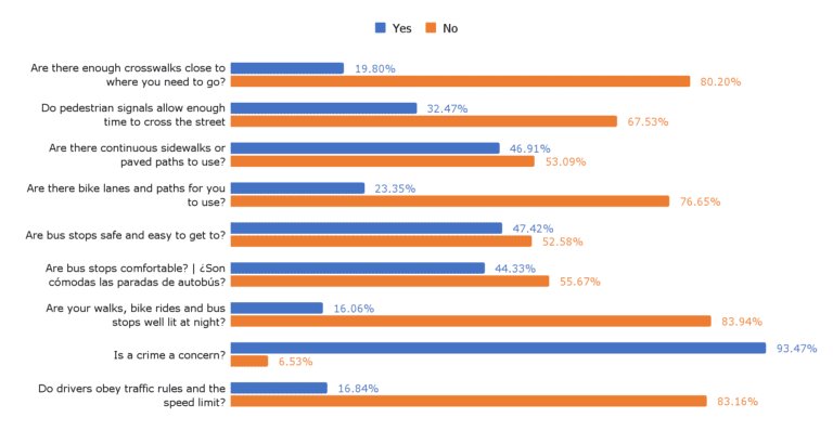
Nearly 94% of survey respondents reported crime being a concern and 84% felt there was inadequate lighting when walking, biking or at bus stops. People who took the survey shared concerns about armed robberies and shootings, and felt the lack of lighting was part of the problem.
83% felt drivers didn’t obey traffic rules or the 40mph speed limit. Several commented that they felt drivers didn’t respect pedestrians as they crossed the street.
More than 75% reported there were not enough bike lanes or paths to ride safely.
More than half said there were not continuous sidewalks to use and that bus stops were not safe or easy to get to. Two thirds felt that pedestrian signals didn’t give them enough time to cross the street.
Aurora Gamez who has lived in Culmore since immigrating from Honduras 20 years ago says, “It’s very dangerous in this area. The road can get up to six lanes wide and often drivers speed down the stretch.” She says the blocks are long with crosswalks available only every quarter mile or so.”
Survey respondents were asked if there are specific areas of concern in Culmore, Route 7 was mentioned most, followed by Glen Carlyn Drive and then Bellview Drive. Also mentioned was Charles Street, the Culmore Shopping Center, and Carlin Springs Road, which is outside of Culmore. Some noted problems of concern in this open ended question. Crossing the street, nighttime crossing, and lighting got the most mentions.
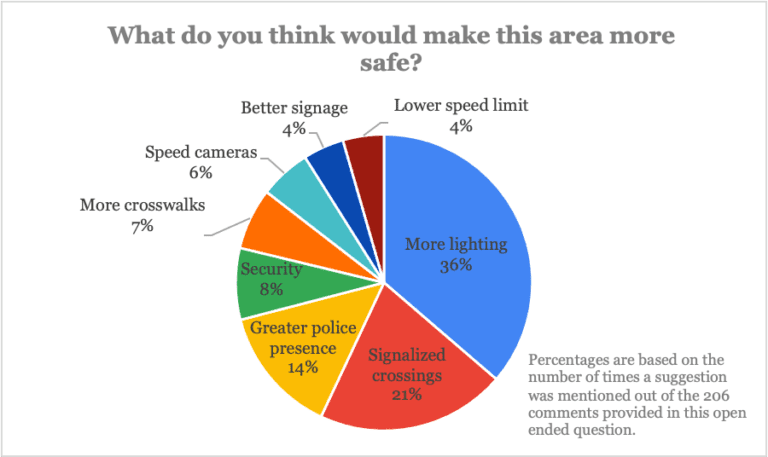
More lighting, signalized crossings and more crosswalks, speed cameras, lowering the speed limit and better signage were the top suggestions offered by survey respondents. There were many additional suggestions including greater driver awareness, continuous sidewalks, bus stop lighting, bike paths, and snow removal.
Community members commented that they would like to see a greater police presence, wanted help to deal with the violence and felt that police would offer a sense of security.
We conducted a walking audit on May 5, 2022, to assess and document firsthand experience of walking along and crossing Route 7 in the Culmore neighborhood. Held during the afternoon rush hour, it provided a good representation of the challenges people face navigating Route 7 on foot or by bike during high traffic. Joining CSG and CASA staff were several Culmore residents, the Fairfax Alliance for Better Bicycling, the Fairfax Families for Safe Streets, and the Mason District representative on Fairfax County’s Trails, Sidewalks, and Bikeways Committee.
While walking a predetermined route, participants used a walk audit checklist developed by 8 80 Cities to take notes on their walking experience, conditions at bus stops, and the state of bicycling infrastructure. The audit observations and recommendations from participants are documented in this report and are intended to augment the survey data to inform transportation and planning efforts for future improvements to the community.
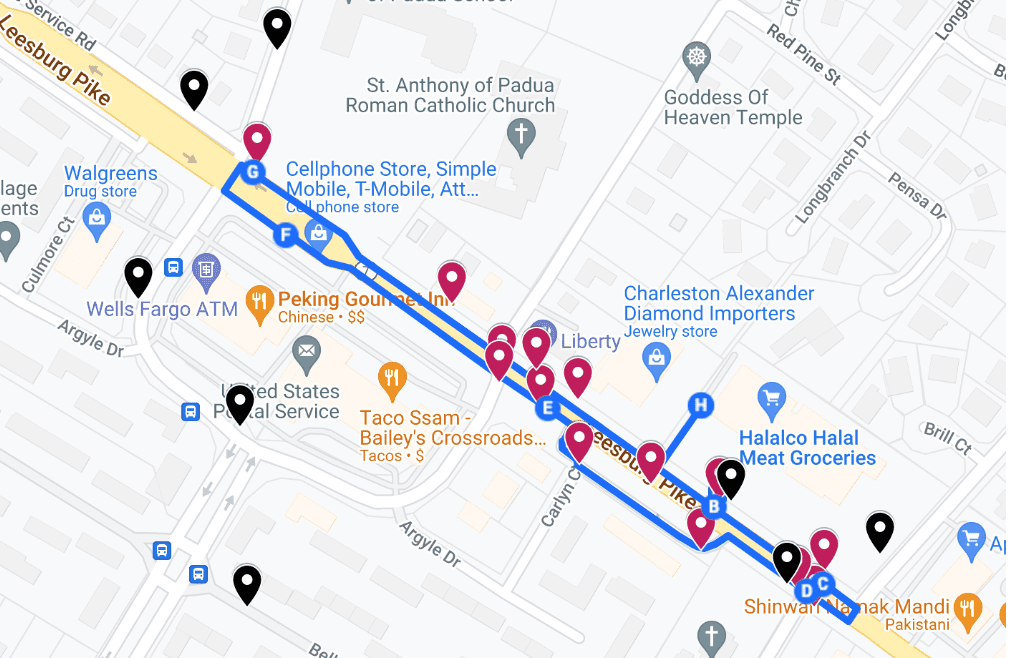
Culmore Walk Audit Route Blue line = walking route / Red markers = Audit observation points Black markers = locations with inadequate lighting
This interactive google map highlights key observations, problem locations and supporting images from the walk audit.
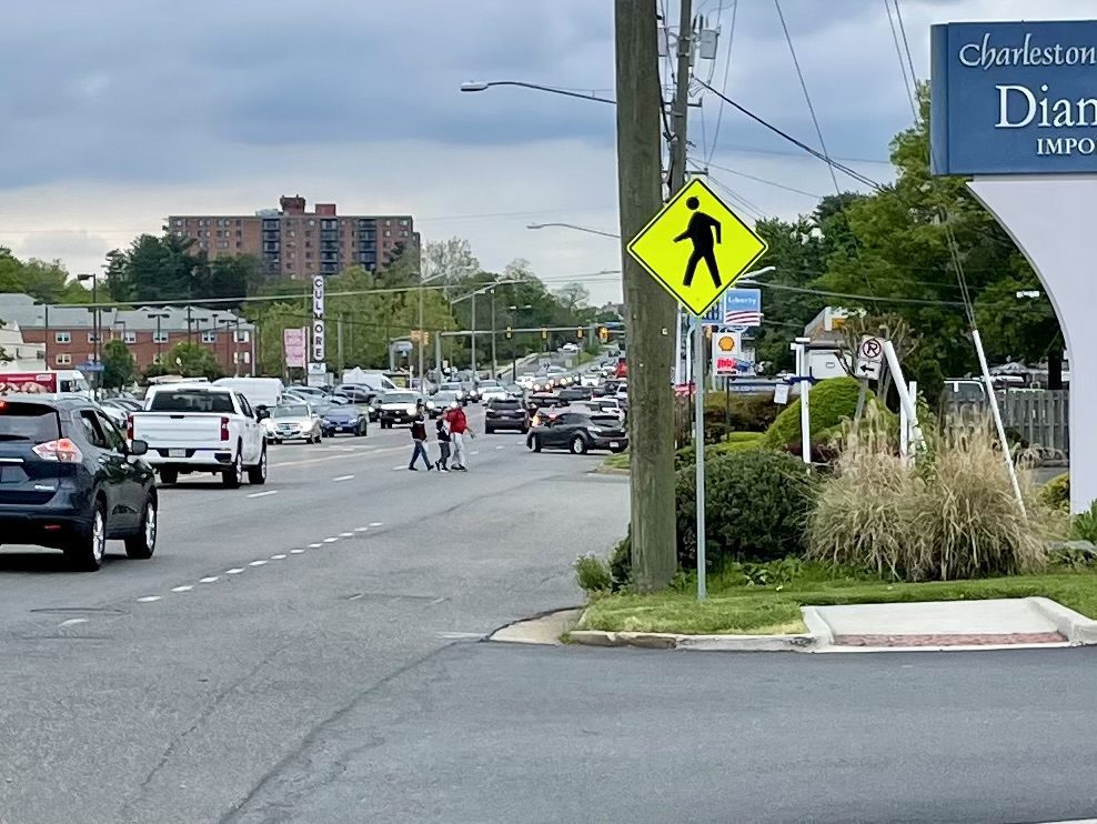
A group of pedestrians cross Route 7 at the Glen Carlyn Dr. and Magnolia Ave. intersection that does not have a crosswalk or signal. This is also the location of a dangerous missing sidewalk connection.
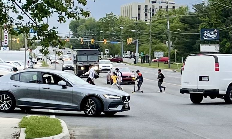
A family with children on scooters crosses Route 7 at Glen Carlyn Dr./Magnolia Ave. intersection that does not have crosswalks or a signal
Based on survey responses and walk audit observations, several needed pedestrian and bicyclist/scooter mobility and safety improvements have been identified and listed below. Fairfax County and VDOT should deploy tactical short-term solutions to save lives now while longer-term solutions are considered and planned. These short-term safety measures can be initiated as pilot projects that can be implemented quickly and then assessed and adjusted as part of longer-term planning.
Ultimately, Route 7 should be redesigned as a walkable, bike-friendly, transit boulevard as part of the Envision Route 7 Bus Rapid Transit project. We urge that all recommended pedestrian and bicyclist/scooter mobility and safety improvements be included in the plans.
Home to a large immigrant population where many residents regularly walk, bike and use the bus, residents are forced to endure the unsafe conditions – which have already taken lives and seriously injured others – as they try to get to work, get the kids to school, run errands and just go about their daily lives. Yet, aside from new sidewalks in a few locations and some safety improvements in the surrounding neighborhoods, the main street through the heart of this community, Route 7, remains unchanged and unsafe.
Through the walkability survey, local community members spoke out from their homes, at the laundromat and out in the Culmore neighborhood, sharing their concerns and what they feel would make it better. Overwhelmingly, they feel unsafe, citing crime, dangerous driving, poor lighting, lack of bike infrastructure, and the lack of connected sidewalks and safe crossing options as the problem
Now is the time to provide the safety improvements the community deserves! Deploying tactical short-term solutions can start protecting lives now while longer-term solutions are considered and planned. Reducing the speed limit, providing additional signalized crossing options, more crosswalks and pavement markings, and brighter pedestrian scale lighting can be an interim step ahead of the Envision Route 7 Bus Rapid Transit project. Ultimately, Route 7 should be redesigned for all users as a complete street that is walkable, bike-friendly, and provides safe and easy access to transit while also providing safe movement for drivers.
© 2024 All Rights Reserved | Privacy Policy | Website designed and developed by IndieTech Solutions